
Share project
Location
Project size
Budget
Tech partner role
Overview
Agroforestry projects help farmers handle erratic weather, but smallholders struggle because the upfront costs for trees, irrigation, and inputs make the switch hard. Carbon finance should subsidize that transition, yet most buyers reject projects because MRV cannot verify tree survival and carbon outcomes cheaply or credibly across many scattered parcels. This blocks funding for the people who need it most and slows climate-resilient farming adoption. The work needs a drone-data plus AI pipeline that scales to larger plot volumes: build a centralized drone data catalog and plot-level source of truth, automate raw-to-dashboard processing with strong QA, and add retraining automation plus batch processing/API access for external users. Ideal team: 6-8 engineers with hands-on experience in geospatial data engineering, computer vision, ML operations, and AWS pipelines, with 5+ years of production scaling experience.
Table of contents
- The problem
- What's already in place
- Project scope
- Users and functionalities
- Data
- Desired expertise
- Success vision
- Supporting resources
The problem
Problem statement
Climate change and erratic weather are making traditional agriculture increasingly vulnerable to crop losses. Labour-intensive farming is harder to sustain as urban migration creates labour shortages. Agroforestry offers a strong alternative: it is more climate-resilient, less labour-intensive, boosts farmer incomes, and provides ecosystem services like biodiversity, soil restoration, and improved water retention.
However, transitioning to agroforestry is difficult for marginal smallholders due to high upfront investments in saplings, drip irrigation, and related inputs. Carbon-financed projects can subsidize these costs, making the transition feasible. Yet carbon markets face a major scalability hurdle: low trust. Buyers and financiers worry about poor data quality, lack of ground-level visibility, over-crediting, double counting, and weak documentation. These challenges worsen when projects involve many small, dispersed parcels, where manual Monitoring, Reporting and Verification (MRV) is expensive, slow, sample-based, and lacks full visibility.
Consequently, marginal smallholders are systematically excluded from carbon finance—not because they lack impact, but because existing MRV systems cannot credibly or affordably verify it at scale.
Our intervention addresses this via an AI-driven digital MRV system built on drone data. It enables transparent, plot-level monitoring of tree survival, growth, carbon outcomes, and implementation quality across all participating parcels. This improves trust, reduces verification costs, and unlocks carbon finance for smallholder-led agroforestry.
To scale this beyond our programs, we offer the technology free of charge, allowing other developers without in-house technical capacity to adopt robust dMRV and scale high-integrity agroforestry projects.
What's already in place
Current tech stack
- Web application
- Mobile application
- Cloud infrastructure
- Data warehouse or database
- APIs or external integrations
- Frontend or user interface
- Backend or core logic
- Data pipelines or databases
- AI or analytics components
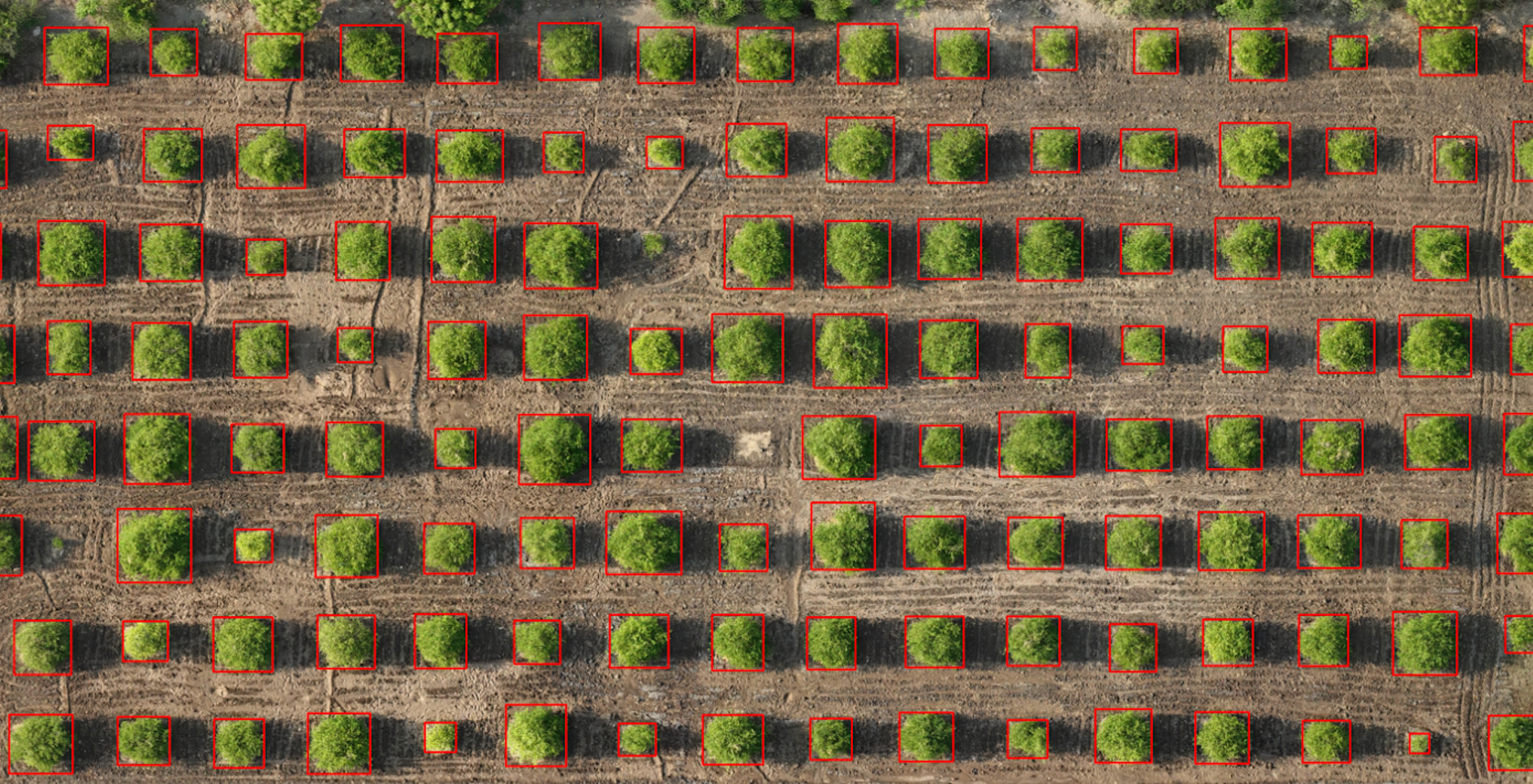
Our MVP is an AI-driven digital MRV system for agroforestry monitoring. The core input is a high-resolution drone orthomosaic: a nadir-view image of a plot where agroforestry plantation has been carried out. If available, a Digital Elevation Model (DEM) can be added as an optional secondary input to allow tree height extraction. The tree detection engine is built on Meta’s Detectron-2 and trained on over 25,000 tree crown annotations spanning small to large trees. Once drone imagery is collected for a plantation, the model analyzes the orthomosaic to detect individual trees, geotag every planted tree, and extract tree dimensions using the DEM. This creates plot-level, tree-level visibility that is not possible through manual sampling. To estimate biomass, we use a Gaussian regressor-based AI model that predicts biomass while also quantifying uncertainty in the estimate. This is important because it improves transparency and helps address concerns around over-crediting and poor-quality carbon estimates. Together, these models generate reliable data on tree survival, growth, and biomass outcomes for each plot. All generated outputs are displayed on a dashboard (https://farmersforforests.org/apps/) that carbon financiers and project stakeholders can access to review all participating parcels. This creates transparent documentation of tree survival and implementation quality across the project, improving trust and making verification more robust. Beyond internal use, we have also deployed the tree detection AI through a free web interface so that other project developers can upload their own data and benefit from the technology without needing in-house technical capacity. This helps scale the impact of the solution beyond our own projects. We have also published a white paper (https://farmersforforests.org/FFF/images/our-tech/tree-lens-white-paper.pdf) documenting the technical details of the AI model development, supporting transparency and broader ecosystem adoption.
Project scope
During the Scaling Program, the technical scope would focus on strengthening the core drone-data and AI pipeline so it can support far larger volumes of plots, organizations, and geographies. A key priority is building a comprehensive drone data catalog by integrating all drone-based GIS data into our central data engineering pipeline and warehouse. This would create a plot-level source of truth for orthomosaics, DEMs, outputs, and metadata, enabling consistent storage, documentation, retrieval, and spatial querying across projects. A second major workstream is end-to-end automation. While we have already automated much of the drone stitching, orthorectification, and DEM generation workflow on AWS, the next phase is to complete the pipeline so that raw drone uploads move automatically through preprocessing, AI inference, QA checks, and dashboard delivery with minimal manual intervention. This includes moving from semi-manual operations toward near-real-time processing and faster results turnaround for partner organizations. Third, we want to build retraining automation into the system. As we work across new geographies, plantation types, and partner datasets, model performance can vary. We therefore want a pipeline that supports dataset audits, annotation workflows, automated data versioning, retraining triggers, evaluation, and redeployment so the models can continuously improve and generalize better as new data comes in. Finally, we want to add new functionality to our public digital platform, TreeLens, especially automated batch processing for external users. Today, TreeLens already allows users to upload drone imagery and receive outputs such as tree detection, tree height estimation, geolocation, and carbon estimation. The next step is to make it more scalable and partner-ready by enabling batch uploads, automated processing queues, improved API access, and a smoother self-serve experience for organizations using the platform without in-house technical teams.
Users and functionalities
External project implementor: upload drone imagery and analyze Carbon financer and funders: dashboard access to visualize project data Internal Farmers for Forests team: analyzing our own carbon project imagery
Data
Data Readiness
- Internal databases or systems
- Spreadsheets or documents
Desired expertise
Tech partner role
ML Engineer DevOps Software Engineer (front and backend)
Success vision
Success would mean that smallholder-led agroforestry is no longer constrained by weak, sample-based monitoring and low trust in carbon markets. In practical terms, our intervention would enable many more farmers to be onboarded into carbon projects, many more acres to be implemented under agroforestry, and a much larger share of these plots to be monitored transparently through digital MRV rather than manual sampling. Success would also mean that other organizations and project developers are able to use this technology in their own projects for monitoring, documentation, and verification, expanding the reach of high-integrity agroforestry beyond Farmers for Forests’ direct programs. A key sign of success would be that carbon finance and implementation funding become easier to unlock because funders, buyers, and auditors have greater trust in the underlying data. With plot-level visibility, better documentation, uncertainty-aware carbon estimates, and continuous monitoring, the technology should reduce concerns around over-crediting, double counting, and poor data quality. This should translate into faster funding cycles, stronger buyer confidence, lower verification costs, and greater willingness to support dispersed smallholder projects that are currently seen as too difficult to monitor. Ultimately, success is not just a better tool, but a measurable shift in value delivery: more farmers included, more acres restored, more partner organizations using the system, and more carbon-linked capital flowing into agroforestry because trust and transparency have improved.
Supporting resources

Farmers for Forests
Our mission is to restore biodiversity and strengthen rural livelihoods by creating biodiverse farms and forests in close collaboration with agrarian and indigenous communities. We work to make agroforestry and ecological restoration financially viable at scale by combining on-ground implementation with rigorous measurement of carbon and biodiversity outcomes. Our long-term vision is to enable this model across 100 million acres of land and directly impact over 100 million farmer lives in India. Our approach is to build farmer- and community-centered restoration systems, and then use technology to make those systems transparent, scalable, and investable. On the ground, we promote agroforestry on farmer lands, often combined with intercropping of pulses and millets, to improve climate resilience, income stability, and ecological health. We work with farming households and forest-dependent communities, and reinvest proceeds from high-quality carbon credits back into expanding participation in the program. A key part of our approach is digital monitoring, reporting, and verification. Using satellites, drones, and open-source AI, we quantify tree survival, health, species, carbon sequestration, and biodiversity-linked outcomes with far greater transparency than manual systems allow. This helps channel more trust and more finance into agroforestry, while also giving farmers better support and improving the credibility of nature-based carbon projects.
Website

.png&w=3840&q=75)